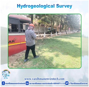
A hydrogeology study or investigation is a study of the subsurface hydrologic and geologic conditions in an area or location. Data are collected about the type and thickness of geologic materials, the occurrence of ground water, how it flows in pore spaces and/or fractures, the quality of the ground water, and what can be expected at wells.
A Hydrogeological Study is undertaken to assess matters such as: groundwater infiltration and recharge, groundwater discharge and baseflow, groundwater elevations and flow paths, water quality and temperature, cumulative watershed impacts, coldwater fisheries supported by groundwater discharge, and impacts to the City’s drinking water sources.
What are the basic data required for hydrological studies?
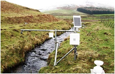
The key variables to be included are precipitation -liquid and solid- (3 or 6 hourly), discharge (naturalised flow, i.e. streamflow corrected for manmade storage; daily), lakes and reservoir levels, soil moisture, snow water equivalent, snow cover area, snow depth, and evapotranspiration.
Before undertaking any artificial recharge project, it is a basic prerequisite to ascertain the availability of source water for the purpose of recharging the ground water reservoir. For determining the source water availability for artificial recharge, hydrological investigations are required to be carried out in the Watershed/Sub-basin/basin where the artificial recharge schemes are envisaged. Four types of source water may be available for artificial recharge viz.
(i) Insitu precipitation on the watershed.
(ii) Surface (canal) supplies from large reservoirs located within basin
(iii) Surface supplies through trans basin water transfer.
(iv) Treated municipal and industrial wastewaters.
‘In situ’ precipitation will be available almost at every location but may or may not be adequate to cause artificial recharge but the runoff going unutilised outside the watershed/ basin can be stored/ transmitted through simple recharge structures at appropriate locations. In addition none, one or both of the other two sources may be available in any of the situations, the following information will be required:
- The quantity that may be diverted for artificial recharge.
- The time for which the source water will be available.
- The quality of source water and the pretreatment required.
- Conveyance system required to bring the water to the recharge site.
Hydrological studies are undertaken to work out surplus monsoon run off whichcan be harnessed as source water for artificial recharge
What does a professional hydro geologist do besides add to the project cost?
Professional hydrogeologists are experienced in specifying and supervising drilling and well tests, such as step tests for performance analysis and aquifer tests, and understanding how test behaviour differs in various media, such as fractured rock and sand/gravel aquifers. Some tasks they perform:
- Aquifer testing and analysis: test drilling, siting new production wells, and site characterization
- Supervise and document production well and observation well construction
- Provide new public water supply well planning support (“OEPA” or “DEQ stuff”)
- Step-testing and analysis for performance and water quality testing for minimizing well interference and well field maximization
- Interpretation of down-hole camera surveys & borehole geophysical logging
- Specific ground water sampling
- Apply appropriate computer-based models to provide a moving view of the hydrogeological setting.
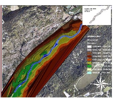
Surface electrical resistivity
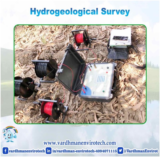
Surface electrical resistivity surveying is based on the principle that the distribution of electrical potential in the ground around a current-carrying electrode depends on the electrical resistivities and distribution of the surrounding soils and rocks. The usual practice in the field is to apply an electrical direct current (DC) between two electrodes implanted in the ground and to measure the difference of potential between two additional electrodes that do not carry current. Usually, the potential electrodes are in line between the current electrodes, but in principle, they can be located anywhere. The current used is either direct current or AC of low frequency. All analysis and interpretation are done on the basis of directcurrents.
The ultimate objective of a Vertical Electrical Sounding (VES) at some locality is to obtain apparent resistivity log similar to, for example, the induction log of a well at the locality, without actually drilling the well. However, because of inherent limitations, the resolution of the VES methods is not as high as that of the induction log.
Geophysical (VES) Survey for getting depth wise in resistivity variation to delineate the aquifer zones ill different hydrological formation by schlumberger and Wenner Methods.
For conducting VES by Schlumberger configuration, the following steps are taken:
- Local Geological and hydro geological conditions of the area.
- Investigation through microprocessor based resistivity meter for measuring the apparent resistivity having facilities to transfer the digital data in storage device.
- The VES will be conducted for minimum of current electrode separation of 200 meters.
- All four electrodes must be collinear and straight line for all the observation points.
- Electrodes alignment and spot location taken every VES by the GPS.
- Four points (two for proposed recharge wells and two for production wells)
How will a hydrogeological investigation help in public water supply decision making?
The investigation helps the public water supply manager to (in a more informed manner):
- Site new wells
- Manage well and total wellfield efficiency
- Track changes in well performance
- Properly delineate a wellhead (source water) protection area
- Provide data on ground water source for long term planning.
Conclusion :
Hydrology is an extremely important field of study, dealing with one of the most valuable resources on Earth: water. … Hydrologists rely on their understanding of how water interacts with its environment, including how it moves from the Earth’s surface, to the atmosphere, and then back to Earth.
“Water from RAINS,
should not end up in DRAINS.”