Aquifer mapping can be defined as a scientific process, wherein a combination of geologic, geophysical, hydrologic and chemical field and laboratory analyses are applied to characterize the quantity, quality and sustainability of ground water in aquifers. Systematic aquifer mapping is expected to improve our understanding of the geologic framework of aquifers, their hydrologic characteristics, water levels in the aquifers and how they change over time, and the occurrence of natural and anthropogenic contaminants that affect the portability of ground water. Results of these studies will contribute significantly to resource management tools such as long-term aquifer monitoring networks and conceptual and quantitative regional ground-water-flow models used planners, policy makers and other stakeholders. Aquifer mapping at the appropriate scale can help prepare, implement and monitor the efficacy of various management interventions aimed at long-term sustainability of our precious ground water resources, which, in turn, will help achieve drinking water security, improved irrigation facilities and sustainability in water resources development in the country as a whole.
Various development activities over the years have adversely affected the ground water regime in many parts of the country. There is a need for scientific planning in development of ground water under different hydrogeological situations and to evolve effective management practices with involvement of community for better ground water governance. In view of the emergent challenges in the ground water sector in the country, there is an urgent need for comprehensive and realistic information pertaining to various aspects of ground water resources available in different hydro-geological settings through a process of systematic data collection, compilation, data generation, analysis and synthesis.
Understanding the importance of sustainable management of ground water resources, several countries have taken up and completed mapping of important aquifer systems. The best known and documented example is that of the USA, where the United States Geological Survey (USGS) has mapped the aquifer systems in the entire country. In the State of New Jersey, New Jersey Geological Survey (NJGS) has recently developed a method for delineating aquifer recharge areas by computing the quantum of ground water recharge by integrating data on rainfall, land use, soil types and surface water. The agency is currently engaged in mapping aquifer recharge areas for the State’s priority watershed areas. In Australia, a national geospatial storage and interpretation system for all hydrologic data is being prepared under an initiative known as “Australian Hydrological Geospatial Fabric” or “Geo fabric” in short. Geo fabric is part of a project called AWRIS aimed at providing nationwide information on water availability, water quality and water usage. In Canada, aquifers of British Columbia region have been mapped. These maps are on 1:50,000 scale and have been prepared on the basis of surface geology maps and borehole logs. Only those aquifers which are being developed are depicted on the maps and sections are drawn to depict sub-surface aquifer disposition wherever data is available. The maps also come with a disclaimer stating that absence of mapped aquifer in an area does not mean absence of aquifers but that sufficient data is not available to delineate and classify aquifers in that area. In the United Kingdom, ground water Protection Policy uses aquifer designations that are consistent with the Water Framework Directive. These designations reflect the importance of aquifers in terms of groundwater as a resource (drinking water supply) but also their role in supporting surface water flows and wetland ecosystems. The aquifer designation data is based on geological mapping provided by the British Geological Survey. It will be updated regularly to reflect their ongoing program of improvements to these maps.
Systematic studies of aquifers and ground water resources in India began the Nineteen Fifties when ground water was considered as a source for supplementing surface water resources for developing additional irrigation potential in the country. It was then that the Exploratory Tube Well Organization (ETO) was formed to identify suitable sites and drilling of tube/bore wells for developmental purposes, while the Ground Water Wing of the Geological Survey of India carried out ground water exploration in different parts of the country. These two organizations were merged into a single entity named Central Ground Water Board in 1972, with a mandate to “Develop and disseminate technologies, and monitor and implement national policies for the scientific and sustainable development and management of India’s ground water resources, including their exploration, assessment, conservation, augmentation, protection from pollution and distribution, based on principles of economic and ecological efficiency and equity”. Over the years, Central Ground Water Board has been taking up hydrogeological studies aimed at deciphering the extents, characteristics, yield potentials and development prospects of important hydrogeological units in the country.
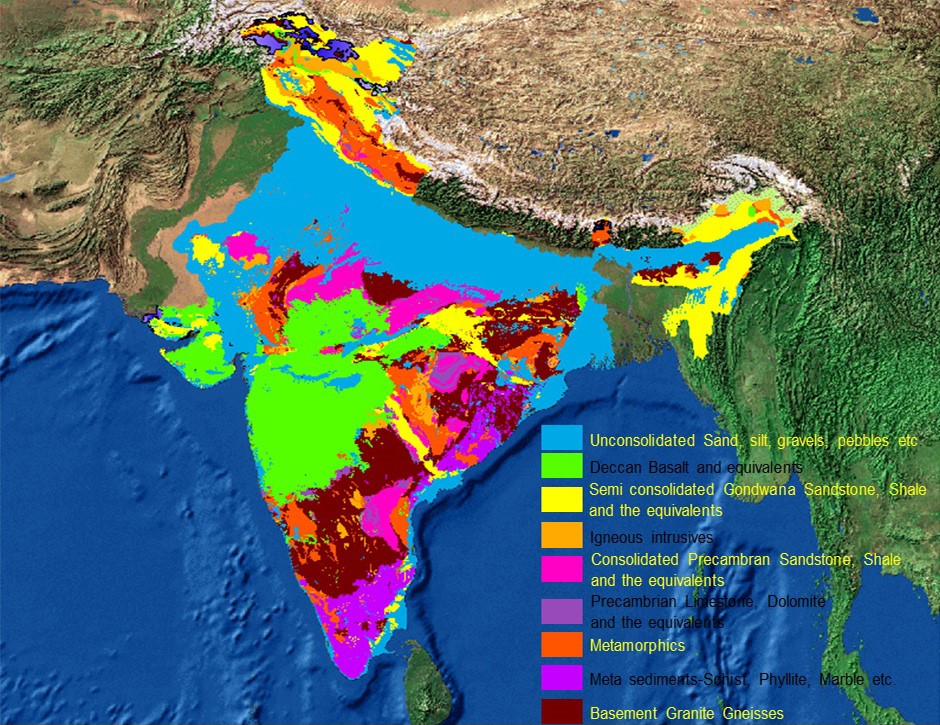
These studies were aided and supplemented by exploratory drilling activities, surface and sub-surface geophysical investigations and ground water quality analyses. These activities resulted in the identification and demarcation of various hydrogeological units suitable to be developed supplement the surface water sources. A number of projects were taken up in major basins of India in collaboration with international agencies to carry out the water balance studies in which groundwater regime‟ of aquifers and its development prospects were studied. With the increasing development of ground water resources to meet rising demands and consequent adverse environmental impacts, the emphasis of hydrological studies of CGWB gradually shifted from development to management aspects from early Nineties. This led to the expansion of activities of CGWB into studies related to ground water augmentation, regulation and integrated water resources management through conjunctive use of surface and ground water resources. Realization of the importance of stakeholder participation in effective ground water management also led to an increase in IEC activities of the Board. In the last decade or so, various activities of CGWB have had “sustainable ground water resource management‟ as the focal theme. As far as maps depicting aquifers are concerned, the first map on Hydrogeology was published by Geological Survey of India in 1969 under the title ” Geohydrological Map of India” on 1: 2Million scale. Subsequently, CGWB published “Hydrogeological Map of India” on 1:5 Million scale with the data updated from the work of CGWB. On the basis of surveys, exploration and special studies undertaken, Central Ground Water Board published its first edition of Hydrogeological Map of India 1:2 Million scale in 1985 and its second edition in 2001. Based on stratigraphy, with the data available at that time, 9 major aquifers (hydrogeological units) were depicted in the map. Subsequently, realizing the increasing importance of ground water as a source of fresh water in the country and in view of the increasing stress on the available resources, the need for demarcation of aquifer units on a larger scale and formulate strategies for their sustainable development was increasingly being felt. This led to the updating of the database of CGWB with data available from the scientific investigations of its own and of various other organizations, which enabled the Board to come out with the first Aquifer Map of the country on 1: 250,000 scale with 14 Principal Aquifer Systems, further classified into 42 major aquifers in the first phase. However, mapping of these aquifer systems at scales of 1: 50,000 or larger is considered necessary for planning their sustainable development with stakeholder participation, for which the current program of National Aquifer Mapping has been launched.
Vardhman Envirotech
India’s Passionate rainwater company
This article is published on : – https://www.aims-cgwb.org/general-background.php
We would like to spread this for the benefit of fellow Indians.